Wildfires

AI Could Snuff Out Wildfires One Power Line at a Time

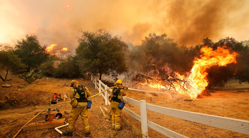
NREL’s Computing Capabilities Could Help Prevent Wildfires Caused by Fallen Power Lines Annually, tens of thousands of wildfires ravage the United States, posing significant threats to people, wildlife, and infrastructure. A percentage of those wildfires are caused by degraded or downed electrical equipment. But what if artificial intelligence (AI) could … [continued]

ChatGPT generated panoramic image of Chicago's skyline shrouded in thick wildfire smoke.

Fighting for Breath: Wildfire Smoke, Climate Change, & the Urgency of Adaptation

Wildfire season is arriving earlier, lasting longer, and burning more intensely than ever before. Communities that once thought of wildfires as rare, late-summer events now find themselves choking on smoke as early as spring. Per FireSmoke.ca, there are over 200 wildfires burning in North America already, and it’s the beginning … [continued]

ChatGPT generated image of panoramic image of a Los Angeles canyon filled with homes and a big question mark hovering overhead

Los Angeles’ $150 Billion Fires Have Lessons For All Urban Planners

The United States, and indeed much of the rest of the world, has been transfixed by the devastation in Los Angeles over the past week. As of January 12, 2025, multiple wildfires are still burning across the Los Angeles area, consuming around 40,000 acres or 62.5 square miles. At least … [continued]

"California Wildfires" by Justobreathe is licensed under CC BY 2.0.

Wildfire Climate Misinformation Is Rampant, And Social Media Platforms Are Promoting It

Devastating consequences of the climate crisis are being submerged by climate misinformation messengers, who are persuaded by a self-serving but very powerful minority to mistrust scientific evidence. In many cases such disbelief emerges from social media affordances, which could actually be tapped as a source for rapid public information dissemination … [continued]

A NASA satellite image from June 8, 2022, reflects smoke and red “hot spots” of wildfire resulting from more than a dozen active fires in southwest Alaska, as the largest tundra fire on record at the time burned hundreds of thousands of acres in the Yukon Delta. Source: NASA MODIS

Biden–Harris Admin Advances Early Wildfire Detection by Expanding Use of Satellites as Part of Investing…

A collaborative agreement for use of NOAA satellites will help the Interior and Agriculture Departments detect wildfires early, track wildfires in real time, and provide data for public safety and air quality modeling The Biden–Harris administration yesterday announced it is taking additional steps to safeguard western communities in the face … [continued]