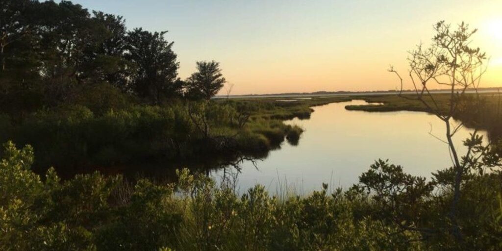
Why Mapping Wetlands With AI Is Important
Support CleanTechnica's work through a Substack subscription or on Stripe.
Chesapeake Conservancy’s data science team developed an artificial intelligence deep learning model for mapping wetlands, which resulted in 94% accuracy. This method for wetland mapping could deliver important outcomes for protecting and conserving wetlands.
“We’re happy to support this exciting project as it explores new methods for wetlands delineation using satellite imagery,” said EPRI Principal Technical Leader Dr. Nalini Rao. “It has the potential to save natural resource managers time in the field by using a GIS tool right from their desks. Plus, it can help companies and the public manage impacts to wetlands as infrastructure builds are planned to meet decarbonization targets.”
What was exceptional about this research? The team trained a machine learning (convolutional neural network) model for high-resolution (1m) wetland mapping.
What is the product of this model? The product of the model is a map of wetland probability. This probability data may be used to map the most likely wetland extent, but if users prefer, they can map wetland extent with a lower probability threshold. The resulting map limits the likelihood of wetland omission even though it maps more wetlands than are present in reality.
What is different about this project? Despite the important role of wetlands data for planning infrastructure projects and managing wildlife, National Wetlands Inventory (NWI) wetlands data have not been comprehensively updated for many years. Much NWI data across the nation dates to the 1970s and 1980s yet remains the best available data. A modeling approach to wetland mapping that can utilize training data of varying vintages will be incredibly useful in modernizing wetland mapping where it is most needed.
What exactly does this mean for protecting and conserving wetlands? The new model will help infrastructure planners avoid wetlands in the planning process, resulting in cost savings and wetlands conservation. Potential beneficial situations include ongoing efforts to expand and develop renewable energy, which requires expanding electric power infrastructure.
What else should we know about the model? The “predictor” layers used in wetland training from which the model learns the patterns found in wetlands were: USDA National Agriculture Imagery Program (NAIP) aerial imagery (1m), Sentinel-2 optical satellite imagery (10-20m), LiDAR-derived geomorphons, an approach to mapping landforms that Chesapeake Conservancy has been applying to advance high-resolution stream mapping; and LiDAR intensity, an index that is frequently used to identify water and persistently wet soils. Additionally, the team trained a simpler model using only USDA NAIP and Sentinel-2 data as the input layers, securing an accuracy of 91.6%.
What ripple effects will this research likely have? “When this highly accurate model is scaled up to predict wetlands in much bigger geography such as the Chesapeake Bay or the contiguous United States, this will be a game changer,” says Chesapeake Conservancy’s Data Science Lead/Senior Data Scientist Dr. Kumar Mainali. “It obviates the need for manual mapping of wetlands as well as mapping wetlands with traditional machine learning which require a lot of data processing, curation, and manual feature engineering, both of which are time-consuming, labor intensive and very expensive.”
Has the model been extended to any other regions? Yes. Following the initial model development, the model was extended to include Lancaster County, Nebraska. Modeling wetlands in this region proved challenging. The NWI data for the area was decades out of date, and it included wetlands in several areas where they had been lost to development.
Why did the team want to work on mapping wetlands in Nebraska? The team was interested to learn whether the model could succeed in mapping wetlands where no recent high-quality wetlands datasets were available to train the model. The wetland model was trained with the decades-old NWI dataset and recent satellite and aerial imagery data.
What were the results of the Nebraska application? The team found that the NWI data improved the local accuracy of wetland mapping by 10% compared to predictions before training, showing the importance of using local training data in new geographies. In addition, the model correctly omitted wetlands where they had been lost to development, despite these wetlands remaining in the outdated training data. The performance of the model in determining the dominant pattern in the data to both improve local mapping accuracy but still accurately reflect wetland presence and absence is promising for the usefulness of this approach.
Are there other possible application for this model? Yes. There could also be potential to use this model to map locations where wetlands have already been lost since they were mapped with NWI. Additionally, potential locations for wetland restoration could also be identified. For example, persistently wet agricultural fields are picked up by the model even though for the purposes of field wetland delineation, these areas are not considered wetlands when actively farmed.
How is the pilot study different than the full model? The full model requires local training data provided by state wetlands data and the NWI. In the meantime, the team will expand the model to states or larger regions and continue to train the model on varied geographies.
Is this mapping data with an artificial intelligence deep learning model timely? “There has never been a better time to invest in updating our nation’s wetland data and establishing a sustainable and cost-effective process for keeping them updated,” explains Environmental Policy Innovation Center’s Restoration Economy Center Director Becca Madsen, a former EPRI researcher.
Where did the researchers get their data sets? They used freely available data from 3 areas: Mille Lacs County, Minnesota; Kent County, Delaware; and St. Lawrence County, New York. Previously, much data for mapping wetlands was quite outdated.
How do we know this data is credible? The results are published in the peer-reviewed journal Science of the Total Environment. (Peer review means that a board of scholarly reviewers in the subject area of the journal, review materials they publish for quality of research and adherence to editorial standards of the journal, before articles are accepted for publication. If you use materials from peer reviewed publications, they have been vetted by scholars in your field for quality and importance.)
What organizations supported this research? EPRI, an independent, non-profit energy research and development institute; Lincoln Electric System; and the Grayce B. Kerr Fund, Inc. were supporters of the Chesapeake Conservancy’s efforts.
Sign up for CleanTechnica's Weekly Substack for Zach and Scott's in-depth analyses and high level summaries, sign up for our daily newsletter, and follow us on Google News!
Have a tip for CleanTechnica? Want to advertise? Want to suggest a guest for our CleanTech Talk podcast? Contact us here.
Sign up for our daily newsletter for 15 new cleantech stories a day. Or sign up for our weekly one on top stories of the week if daily is too frequent.
CleanTechnica uses affiliate links. See our policy here.
CleanTechnica's Comment Policy