Fight Fire With — AI? Artificial Intelligence Tackles Wildfires
With wildfires blazing across Canada and blotting out the sun in much of America’s Midwest and Western Europe, not to mention the onset of California’s “wildfire season,” the rush is on to create better early response technology and even ways to precisely predict breakouts and early intervention, which offers the best chance of controlling wildfires. Now, a company called Pano AI is using new data models and continuous surveillance to help catch fires as soon as they start, and before they run wild.
Pano AI is currently building out the largest blaze-detecting network in the Pacific Northwest, monitoring some 2.4 million hectares (about 6 million acres) of land across California, Colorado, Oregon, Washington, Idaho, and Montana and using real-time fire hazard detection and assessment to alert of response teams, early, potentially saving time that could mean the difference between containment and tragedy.
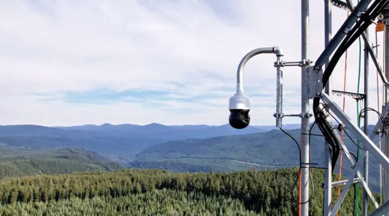
The system uses 360-degree-scanning cameras (as seen, above) installed in high vantage points that continuously survey the surrounding areas for signs of smoke. The cameras, which can see 15 miles in every direction, record high-definition video and apply “deep learning” to recognize fires. Once a fire is detected, the AI model assess the threat, pinpoints their location, and reports on the fire’s expected spread’s speed and direction, enabling response teams to properly triage the situation.
AI Uses Digital Cameras to Spot Signs of Fire

“Our team at Pano is made up of former fire professionals as well as world class technologists who have come together to build the best possible tools for first responders,” said Arvind Satyam, Chief Commercial Officer and a founding member of Pano AI, which also recently announced 14 new surveillance posts to monitor the Green Triangle, a rugged area of bushland across south-east Australia.
 Chip in a few dollars a month to help support independent cleantech coverage that helps to accelerate the cleantech revolution!
“The Green Triangle plantation forest region is one of the powerhouses of the Australian forest and forest products industry,” offers Australian Premier Peter Malinauskas. “The South Australian portion of the region contributes more than $860 million to South Australia’s gross state product annually, making it one of the state’s most productive sectors.”
Wildfires have been estimated to cause more than $50 billion in damage annually, with untold value in human and wildlife cost. What’s more, 6,450 “megatonnes” of CO2 were released into the atmosphere in 2021 (and more, potentially, in 2022) as a direct result of uncontained wildfires — and that’s just a single year. Since 2000, there have been 1.5 million wildfires in the US, and more than 18,000 reported fires burning more than 500,000 acres as of June 1, 2023, alone.
Source | Images: Pano AI, via Gov’t of South Australia, New Atlas.
Have a tip for CleanTechnica? Want to advertise? Want to suggest a guest for our CleanTech Talk podcast? Contact us here.
Latest CleanTechnica.TV Videos

CleanTechnica uses affiliate links. See our policy here.
CleanTechnica's Comment Policy